

When stranded in the ocean, determining your location is crucial for survival and rescue. GPS technology provides accurate positioning using satellites, even in the middle of the ocean.
However, its effectiveness depends on factors like signal strength, battery life, and the type of GPS device used. Understanding how GPS works in open water, its limitations, and how to properly use it can significantly improve your chances of being rescued.
GPS (Global Positioning System) is a satellite-based navigation system that provides real-time location data anywhere on Earth. It is widely used in navigation, including marine travel, aviation, and emergency rescues.
Contents
- 1 How GPS Works in Open Water
- 2 Can GPS Devices Function Without Internet or Cell Signal?
- 3 Types of GPS Devices Suitable for Ocean Navigation
- 4 Satellite GPS vs. Mobile GPS: Key Differences
- 5 Challenges of Using GPS While Stranded in the Ocean
- 6 How to Get GPS Coordinates in an Emergency
- 7 The Role of Emergency Beacons (EPIRBs & PLBs) in Ocean Survival
- 8 How to Conserve Battery Life on GPS Devices in the Ocean
- 9 How Rescue Teams Use GPS to Locate Stranded Individuals
- 10 Survival Tips When Using GPS in Open Water
- 11 Frequently Asked Questions about Can You Use GPS While Stranded in the Ocean
- 12 Conclusion on Can You Use GPS While Stranded in the Ocean
Key Features of GPS
- Satellite-Based System: GPS devices receive signals from multiple satellites to determine an exact location.
- Global Coverage: Works in almost all locations, including oceans, deserts, and mountains.
- Accuracy: Most GPS receivers provide precise coordinates within a few meters.
- No Internet Required: Unlike mobile phone location services, GPS functions without cellular data or Wi-Fi.
GPS plays a vital role in maritime navigation and survival situations. Understanding how it works is essential when stranded at sea.
How GPS Works in Open Water
Satellite Connectivity in the Ocean
- GPS operates through a network of at least 24 satellites orbiting the Earth.
- In open water, the absence of buildings or mountains ensures a clear line of sight to satellites.
- A GPS receiver calculates its position by triangulating signals from multiple satellites.
Challenges in Open Water
- Weather Conditions: Heavy storms and cloud cover can sometimes weaken satellite signals.
- Wave Interference: Extremely high waves can temporarily block signals.
- Device Quality: Not all GPS devices have strong antennas or accurate positioning capabilities.
Even with some challenges, GPS remains the most reliable tool for location tracking in the ocean.
Can GPS Devices Function Without Internet or Cell Signal?
One of the biggest misconceptions about GPS is that it requires an internet connection. In reality, standalone GPS devices work independently of cellular networks.
Types of GPS That Work Without Internet
- Dedicated GPS Receivers: These handheld devices use only satellite signals for location tracking.
- Marine GPS Units: Installed on boats, these systems offer navigation, mapping, and emergency features.
- Personal Locator Beacons (PLBs): These emergency devices send distress signals with GPS coordinates.
Why Cell Phones May Not Work
- Most smartphones rely on Assisted GPS (A-GPS), which uses cellular networks for faster location detection.
- Without internet or a cell signal, many phone-based GPS apps become unreliable.
- Standalone GPS devices remain the best option for ocean navigation and survival.
Different GPS devices are designed for various situations. When stranded in the ocean, using the right type of GPS device can determine the speed and success of your rescue.
Handheld GPS Devices
- Compact and easy to carry.
- Runs on batteries, making them ideal for emergency use.
- Provides detailed maps and coordinates.
Marine GPS Systems
- Installed on ships and boats.
- Offers advanced navigation and tracking features.
- Requires power sources, making it unsuitable for personal survival situations.
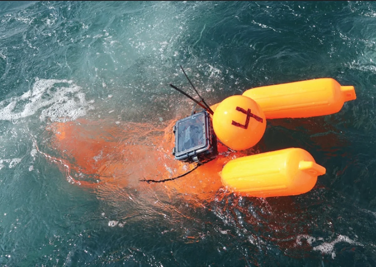
Emergency Locator Beacons (PLBs & EPIRBs)
- PLBs (Personal Locator Beacons): Compact, manually activated emergency beacons that send GPS signals to rescue authorities.
- EPIRBs (Emergency Position Indicating Radio Beacons): Used on boats, automatically activated when submerged in water.
Choosing the right GPS device depends on your situation, but PLBs and handheld GPS units are the best choices when stranded in the ocean.
Satellite GPS vs. Mobile GPS: Key Differences
Not all GPS systems work the same way. Some rely entirely on satellites, while others need internet or cellular signals to function.
Satellite GPS
- Works anywhere in the world, including the ocean.
- Uses signals from multiple satellites for accurate positioning.
- Found in handheld GPS devices, marine systems, and emergency beacons.
Mobile GPS
- Requires a cell network or internet to function properly.
- Common in smartphones and navigation apps.
- May stop working in remote ocean locations without service.
For survival at sea, satellite-based GPS devices are the only reliable option.
Challenges of Using GPS While Stranded in the Ocean
![]()
Despite its reliability, GPS technology has limitations in survival situations.
Battery Life Issues
- GPS devices consume power quickly, especially when continuously tracking.
- Always carry spare batteries or a solar charger to extend usage.
Signal Interference
- Strong storms and high waves can occasionally block signals.
- Moving to an open, elevated position improves signal reception.
Device Durability
- Not all GPS devices are waterproof or floatable.
- Using a waterproof case or securing the device to a flotation device is essential.
Being aware of these challenges can help you prepare for an emergency.
How to Get GPS Coordinates in an Emergency
When stranded in the ocean, getting and communicating your GPS location is crucial for rescue operations.
Steps to Retrieve GPS Coordinates
- Turn on Your GPS Device: Allow it to connect to satellites.
- Wait for Accurate Positioning: GPS may take a few minutes to lock onto signals.
- Note Your Latitude & Longitude: Write down your exact coordinates.
How to Send GPS Coordinates for Rescue
- Use a Radio or Satellite Phone: Call emergency services and provide your location.
- Activate an Emergency Beacon (PLB/EPIRB): These devices automatically send your location to search-and-rescue teams.
- Mark Your Position: If drifting, note the direction of movement for better tracking.
Knowing how to retrieve and communicate your GPS location can mean the difference between life and death when stranded at sea.
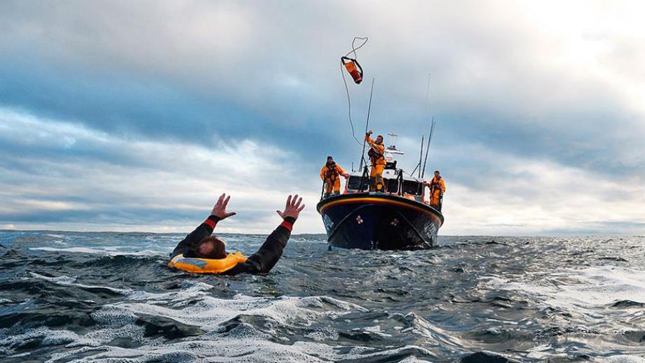
The Role of Emergency Beacons (EPIRBs & PLBs) in Ocean Survival
When stranded in the ocean, Emergency Position Indicating Radio Beacons (EPIRBs) and Personal Locator Beacons (PLBs) play a crucial role in rescue operations. These devices transmit distress signals with GPS coordinates to search-and-rescue teams, significantly increasing survival chances.
What Are EPIRBs and PLBs?
- EPIRBs (Emergency Position Indicating Radio Beacons): Designed for boats and ships, EPIRBs are automatically activated when submerged in water or manually triggered in an emergency.
- PLBs (Personal Locator Beacons): Smaller, portable devices carried by individuals. Unlike EPIRBs, PLBs must be manually activated to send distress signals.
How Do These Beacons Work?
- When activated, the beacon sends a distress signal containing GPS coordinates to satellites.
- The signal is relayed to search-and-rescue authorities (such as the Coast Guard).
- Rescue teams use the transmitted location to initiate an operation.
Why Are They Essential for Ocean Survival?
- No Internet or Cellular Signal Required: EPIRBs and PLBs rely solely on satellite signals.
- Highly Accurate Location Tracking: Ensures faster rescue response times.
- Waterproof and Durable: Designed for harsh ocean conditions.
Carrying an EPIRB or PLB can make the difference between life and death when stranded at sea.
How to Conserve Battery Life on GPS Devices in the Ocean
GPS devices are essential in survival situations, but battery life is a major concern when stranded in the ocean. Knowing how to extend battery life ensures prolonged access to location tracking.
Tips to Extend GPS Battery Life
- Use Power-Saving Mode: Most GPS devices have a low-power mode that reduces battery consumption.
- Turn Off Unnecessary Features: Disable Bluetooth, backlight, and sound alerts to save power.
- Use GPS Only When Needed: Turn off the device when not actively tracking.
Emergency Power Solutions
- Solar Chargers: Lightweight and effective for recharging GPS devices in open water.
- Hand-Crank Chargers: Useful for generating power manually in survival situations.
- Backup Batteries: Carry spare batteries or a power bank for extended use.
Avoiding Battery Drain
- Keep the GPS dry and at a stable temperature to prevent battery degradation.
- Store it in a waterproof case to avoid exposure to saltwater.
Proper battery management can significantly improve survival chances in an emergency.
Alternative Navigation Methods Without GPS
If GPS fails, understanding traditional navigation methods is crucial for survival in the ocean.
- The Sun: The sun rises in the east and sets in the west—use this to determine direction.
- The North Star (Polaris): In the Northern Hemisphere, Polaris always points north.
- Southern Cross Constellation: In the Southern Hemisphere, this star formation helps identify south.
Observing Ocean Currents and Winds
- Currents and tides move in predictable patterns—following them can lead to land.
- Wind direction can indicate which way to drift.
Reading Clouds and Wildlife Patterns
- Clouds: Thick cloud formations over the horizon often indicate land nearby.
- Birds: Seabirds fly close to shore—following them may lead to land.
Without GPS, using nature as a guide can improve survival chances in open water.
How Rescue Teams Use GPS to Locate Stranded Individuals
Search-and-rescue teams rely heavily on GPS technology to locate people stranded in the ocean.
How GPS Assists in Rescue Operations
- Satellite Tracking: GPS beacons send real-time location data to rescue teams.
- Aircraft & Ship Navigation: GPS helps pilots and captains navigate precisely to the distress signal.
- Search Pattern Optimization: Teams use GPS to plan efficient search routes.
Steps in a GPS-Assisted Rescue Mission
- Distress Signal Received: A PLB, EPIRB, or SOS call transmits the stranded individual’s GPS coordinates.
- Search-and-Rescue Deployment: Authorities dispatch helicopters, boats, or planes to the location.
- Rescue Execution: Once the target is identified, specialized recovery teams retrieve survivors.
GPS allows for faster, more efficient rescues, reducing the risk of prolonged exposure to harsh ocean conditions.
Survival Tips When Using GPS in Open Water
Using a GPS device correctly in an ocean survival situation can increase the chances of rescue.
Best Practices for Using GPS in the Ocean
- Keep the GPS Waterproofed: Use a sealed case to protect against water damage.
- Monitor Battery Life: Use power-saving mode and turn it off when not needed.
- Store Coordinates: Write down important GPS coordinates in case the device fails.
What to Do After Getting Your Location?
- Send a Distress Signal: Use a radio, emergency beacon, or satellite communicator.
- Stay in One Location: Moving around may make it harder for rescuers to find you.
- Use Reflective Signals: If visible to aircraft, use a mirror or bright object to attract attention.
Understanding how to use GPS effectively can greatly improve survival odds.
Frequently Asked Questions about Can You Use GPS While Stranded in the Ocean
Can a smartphone GPS work without internet in the ocean?
Most smartphones rely on assisted GPS (A-GPS), which requires internet or a cell signal. Standalone GPS devices or emergency beacons are recommended.
What is the best GPS device for survival at sea?
A Personal Locator Beacon (PLB) or Emergency Position Indicating Radio Beacon (EPIRB) is the most reliable GPS device for ocean emergencies.
Do high waves affect GPS signals?
While GPS signals can penetrate clouds and weather conditions, extremely high waves may temporarily block the signal.
How long does a GPS battery last in an emergency?
Battery life varies, but power-saving mode and spare batteries can extend usage. Some GPS devices last 12–48 hours on a full charge.
Can I use a GPS watch for navigation in the ocean?
Yes, but marine-grade GPS devices or emergency beacons are far more reliable for long-term survival situations.
Conclusion on Can You Use GPS While Stranded in the Ocean
GPS technology is a critical tool for survival in open water, providing accurate location tracking for both individuals and rescue teams. Standalone GPS devices, emergency beacons (EPIRBs & PLBs), and marine GPS systems offer the best reliability in ocean navigation.
While GPS is highly effective, backup survival strategies are essential in case of device failure. Battery conservation, alternative navigation techniques, and distress signal communication increase the likelihood of successful rescue.
For anyone venturing into open water, carrying a dedicated GPS survival device is non-negotiable—it can mean the difference between life and death.